A clothes line amidst the fennel stalks.

DSCN4822 2 pixlr signed

A clothes line amidst the fennel stalks.

A hot August morning on Comino. The rising sun’s heat is tempered by the occasional straggling cloud providing a few overcast seconds of relief and a stiff breeze of Majjistral, Malta’s prevailing north west wind which is nature’s alternative to refreshing air conditioning.

We are on our annual pilgrimage to this desolate little island. Arid, but full of life. Ruggedly beautiful with ever changing scenery. A two and a half square kilometre island. One tiny corner of which, its Blue Lagoon, is over-run by up to five thousand visitors daily. Leaving the rest to people like us. A fair deal, I think. Amazing how even on such a small landmass, you can just climb the small hill overlooking Cominotto Island and all evidence of the crowds dissipates into thin air. No sight, no sound. Nothing.

We have climbed from the inlet of San Niklaw and walked across Comino’s main thoroughfare, Triq Kemmunett. At the location of the old Bakery building we take a sharp right and climb steeply up Triq il-Gvernatur, the road leading to the imposing Santa Maria Tower, part of a network of coastal watchtowers built by the Knights of St. John.

Our final destination today is the small mooring place at Wied Ernu, a tiny cleft in the island’s southern coast which used to serve as the landing for boats from Malta during the time of the twentieth century agricultural colony on Comino.

The colony is long gone, but its remains, mostly in ruins and disrepair are spread all over the island.

On the way back, a small sign of human activity. One of the handful of people which stayed behind when the colony disbanded in the late 1960s. True Comino-born and bred. Hanging clothes to dry on a line. Surrounded by stalks of wild fennel.

A beautiful sight. A sign of humanity’s resilience and adaptability. And oneness with nature.

The fresh breeze, the aromatic smell of ripening fennel seeds and the slight waft of damp, clean laundry hanging out to dry in the wind. Elements which make me return to Comino year after year.

Snapshot from a historic garden

17845800130_024ae78eff_o

Snapshot from a historic garden

For most people, the suburb of Floriana is merely a place of transit en route to Malta’s capital Valletta. This is indeed a pity, for Floriana, in spite of its relatively small size, features a rich variety of places to visit, foremost amongst which its numerous public gardens, mostly on the extensive network of fortifications which were built as an outer buffer to the massive bulwarks defending Valletta itself.

One of the oldest of these gardens is the Argotti Botanic Gardens on the Marsamxett Harbour flank of Floriana.  The garden’s oldest parts date back to 1741 when they served as the private domain of the Portuguese Grandmaster of the Order of St. John in Malta Dom Fra’ Manuel Pinto da Fonseca.  They were later cared for and extended by the Bailiff Ignatius de Argote et Gusman from whose family name the corrupted name Argotti originated.

During the Knights’ period, the gardens were used to grow medicinal herbs and plants bearing in mind the Order’s Hospitaller vocation only to be later transformed into the Botanical Gardens we see today during the early years of the British period in 1805.

Amongst the Argotti Garden’s treasured possessions one finds an extensive and internationally recognised collection of potted cacti which are available for public display in the enclosed area managed by the University of Malta and which is generally accessible by appointment with the Curator during office hours.

The photo which is the subject of this short entry shows an area of dense foliage in the Gardens which is dominated by an impressive giant cactus which looks like some surreal creation from Salvador Dalí’s paintbrush.

The Neo-Gothic building in the background is the Wesleyan Methodist Church which was designed by architect Thomas Mullet Ellis in 1881 and was completed in 1883 under the direction of Poulsen. It was inaugurated for religious worship on the 18th March 1883.

A snapshot of yet another of those nonchalantly and perfectly co-existing Maltese paradox landscapes: a decades old New World cactus flanked by a South East Asian ficus and a North African date palm in a herb garden designed by eighteenth century Catholic warrior monks with a nineteenth century Protestant place of worship filling up the background!


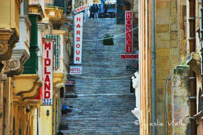
The Stepped Streets of Valletta


16272079891_24d05671b0_o

“Adieu, ye cursed streets of stairs, how surely he who mounts you swears”

Thus did Lord Byron describe the stepped streets of Valletta during his twenty day visit to Malta between August 31 and September 19, 1809 when he was forced into an extended stay, mainly due to quarantine following an outbreak of yellow fever in his previous port of call.

Following a few miserable days on board, made worse by the customary September hot and humid weather conditions, he was eventually allowed to disembark and visit Valletta.   At that time, the best way to reach upper Valletta on foot was via an interminable staircase which started near today’s fish-market (the infamous Nix-Mangiaris steps) and climbed steeply until they linked with the stepped part of St. Ursula Street all the way to Castille Square.

Byron suffered from a limp, and having to negotiate Valletta’s stepped streets in the sweltering humidity of September must have been a huge effort which stressed him to the point of putting pen to paper to create the spiteful, nevertheless immortal, lines quoted above.

DSCN9385 2 pixlr signed

But this short essay is not about Byron’s short sojourn but about Valletta’s stepped streets.   The streets are today taken for granted by most Maltese as an integral part of the City’s street-scape.

Valletta is built on a spit of land jutting between two deep-water harbours. A nineteenth century visitor once described Valletta as a city built “on a hog’s back, a narrow but high neck of land dividing the Grand Harbour from the Quarantine Harbour”. The same visitor vividly goes on to describe the City’s main streets as running “in parallel lines along the said hog’s back”, while being regularly intersected “by others which run up and down its steep sides”. He then concludes by stating that, “in some parts they are so steep that flights of steps take the place of the carriage-way”.

DSCN9369_Painterly pixlr signed 2

When the Knights of St John were planning the city, as a modern renaissance town combining the best of military architecture together with the latest trends in street layout and infrastructural design, they apparently tried, as much as possible, to minimise the annoying limitations brought about by the “hog’s back” contours of the Xiberras Peninsula.

In fact they managed to use rubble to flatten as much as possible of the area between City Gate and St. George’s Square where they built the Grandmaster’s Palace together with an almost similar stretch of Merchants Street except for the hilly upper part which led to Castille Square.

As to the steep side streets: the only way they could negotiate these impossible gradients was to use steps, creating a practical way to make otherwise difficult slopes negotiable by pedestrians. Some of the streets were stepped across their entire width while others had a smooth surface but had pavements (sidewalks for our American readers) made of steps.

13929410680_e0e06ed4c1_o

Given the tendency of most Maltese-sourced masonry to become polished and very slippery upon extensive use, the designers countered this by using a very scarce, today almost exhausted, source of hardstone: a particularly hard type of coralline limestone known colloquially as żonqor for the steps to ensure durability and a non-slip surface. It is, in fact, amazing that these stone surfaces, evenly pitted with a pickaxe to provide a better grip, remain intact after hundreds of years of use!

If you are a local who regularly walks past these steps and stepped streets with a sense of déjà-vu, do pause for a moment to admire their style and practicality. And if you are a visitor, do make sure to spend some time to experience negotiating these stepped streets which give Valletta yet another unique touch to the many it surprisingly contains within its minuscule dimensions.

8037212181_a08c08e2c3_o

Malta’s oldest fortification

Malta’s oldest fortification

DSCN0053 pixlr signed

Mention Maltese fortifications and one’s mind is automatically transported to the impressive and extensive defensive systems designed and constructed during the period of the Knights of St. John of Jerusalem, more popularly known as the Knights of Malta.   The most impressive of the Knights’ fortifications include the walls of Valletta and Floriana, the Cottonera Lines encompassing the Three Cities of Vittoriosa, Cospicua and Senglea and the walled citadels of Mdina and Victoria on Gozo.

The British also left some impressive fortifications the most famous of which are the Victoria Lines which criss-cross the island at its widest breadth between Madliena and Fomm ir-Rih. Older medieval fortifications, some dating from the Byzantine and Arab period, are found in Vittoriosa, Mdina and the Gozo Citadel where they were incorporated into the Knights’ battlements. A couple of locations such as San Gwann also feature the remains of Roman towers which presumably had some sort of military significance, albeit of an observatory nature.

DSCN0030 pixlr signed

By far, the oldest evidence of a fortified structure to have been found in Malta is the impressive wall protecting the remains of the Bronze Age village at Borg in-Nadur in Birzebbuga on the south-eastern tip of the island of Malta.

DSCN0054 pixlr signed

Borg in-Nadur has a very interesting history. It lies at the tip of the Wied Dalam valley where around half a kilometre upstream lies Ghar Dalam, the Cave of Darkness after which the earliest phase of Maltese prehistory is named. The Ghar Dalam phase dates back to around 5000BCE and is reputed to contain the oldest evidence of human activity in the Maltese Islands: settlers who came from Sicily by crossing the 100 kilometre stretch of sea on rafts and boats bringing with them seeds, livestock, fabrics and pottery which has been matched with artefacts from a south-eastern Sicilian prehistoric site called Stentinello.

DSCN0127 hdr pixlr signed

Borg in-Nadur started life around 2,500BCE as a Tarxien-phase temple. It was a relatively small and undecorated temple on a promontory overlooking the protected expanse of Marsaxlokk harbour.  After around a thousand years as a temple, the site was taken over by a new wave of Bronze-Age settlers around 1500BCE who differed principally from their Neolithic predecessors owing to their introduction of metal tools, implements and weapons to the Islands. The Bronze Age settlers occupied Borg in-Nadur for a thousand years until 500BCE when the literate Phoenicians reached these shores and transported Malta into the historic age.

The Bronze-Age settlers redeveloped the site quite extensively into a sizeable village. They recycled a lot of the stones from the temple complex and built their huts in the general area of the older temple site. Hut foundations were excavated by Margaret Murray in the 1930s but were buried once more once the necessary studies were conducted.   The village seems to have been quite large housing a few hundred residents and also featured around one hundred grain silos excavated as bell-shaped cisterns in the soft globigerina limestone around the coast.

DSCN0062 pixlr signed

Most of the silos were destroyed in two episodes of road construction and widening in the twentieth century but a handful survive on a thin coastal stretch across the road from the main site: silos which have their own unique story to tell owing to the fact that most of them lie under sea level suggesting either a rise in sea levels over the past couple of thousand years or else land subsidence. This story is further corroborated by the presence of a single, adjacent set of cart-ruts which also lead straight into the sea.

DSCN0027 pixlr signed

Evidence indicates that the Bronze-Age inhabitants were more warlike than their predecessors, although it is not clear whether their bellicose behaviour extended to the threat of foreign seafarers or other clans inhabiting other parts of the Island.

DSCN0034 pixlr signed

One of the most impressive and clear indications of the troubled times in which these people lived, is the extensive 4.5 metre high semi-circular wall which lies at the northern end of the Borg in-Nadur village. The wall was excavated by Murray in the 1930s and contrary to most of the dig carried out then, it was not reburied. The original remains of the wall were augmented by modern reconstructions especially in the back part. The entire structure is about 30 metres long and circa 2.5 metres thick. The most impressive aspect of this 3,500 year old wall is the huge rock boulders which are embedded within the structure: megaliths which were probably recycled and reused from the original temple.

DSCN0042 pixlr signed

An intriguing aspect of the Borg in-Nadur defensive wall is that it actually faces inland rather than towards the sea! Does this mean that the villagers were more interested in defending themselves from the enemy within or is there another unknown significance?

Whatever the interpretation, this small and relatively unknown site has its special place in Malta’s impressive list of historical treasures: the first in a 3,500 year fortress-building tradition making Malta one of the most well-defended locations in the Mediterranean.

11091143_10205331410817621_1612580066_n

The watchers

11713995835_a792548733_o

The watchers

The date: sometime in mid January

The time: around 17:00

The place: Ghajn Tuffieha, Malta

A Maltese January evening, just ahead of sunset.  The bearing: due west, as the sun sets after a short sojourn across the winter sky, a mere three weeks after the December solstice marking the shortest day of the year.  Beyond the horizon, the distant Tunisian shoreline, on the African coast.

There is no wind and the open sea appears calm.  Broken clouds provide for an intermittent cover of the otherwise blue sky.  A myriad of all the colours of the spectrum emanates from the fading orb of the setting solar disc.

The unfolding scene has its watchers, both animate and inanimate.

A group of human watchers, most probably tourists from some inland city up north, enjoying the rare spectacle of a maritime sunset and absorbing the unfolding scene.  Free entertainment, which no expensive man-made wonder can ever replace.

To their right, another watcher, standing in stony silence.  A watchtower from the time of the Knights of Malta; one of a network built to watch the coast for marauding ships and to raise the alarm through the timeless method of smoke signals, as ancient as humanity itself.

The perfect silhouette, the beautiful colors of the sunset and the focus on the watchers: elements comprising a photo I count among my favourites, and which I feel compelled to share.

Malta’s Rosetta Stones

cippus1pixlr signed

Malta’s Rosetta Stones

Everybody is familiar with the Rosetta Stone, the ancient stone stele containing three almost similar inscriptions written in Ancient Egyptian Hieroglyphics,  Demotic Script and Ancient Greek.  This stone was used by the great French linguist Jean-Francois Champollion to sensibly decipher Egyptian hieroglyphs for the first time in 1822, thus opening the way for the eventual understanding of the previously undecipherable multitude of Egyptian inscriptions and papyri .  In turn, this helped us understand day to day life in Ancient Egypt in a way unprecedented until the deciphering became possible.

Within the Maltese context, a lesser known set of stone candelabra, or ornamental pillars known as cippi (plural of cippus) were used in a similar fashion to decipher the Phoenician alphabet for the first time in the late seventeenth century, making them Malta’s equivalent of the Rosetta Stone.  What and where are these cippi?

cippus2pixlrsigned

The two white marble candelabra were discovered within the multi-period sanctuary site of Tas-Silg near Marsaxlokk in the south of Malta  in the late seventeenth century during the period of the Knights of Malta.  Tas-Silg is a very important Maltese archaeological site because it features a continuous, uninterrupted use spanning all eras from the Neolithic to the fourth century AD.  Within this time-span, the site served as a religious sanctuary containing layer upon layer of Stone Age, Bronze Age, Punic and Paleo-Christian places of worship.  The candelabra have been dated to the Punic (Phoenician) phase of the Tas-Silg site when the place was a Sanctuary of the Goddess Juno (Astarte to the Phoenicians).  They date to around 200 BCE.

The discovery of these two candelabra within the grounds of a Phoenician temple in Malta suggests that they were votive offerings in gratitude for prayers heard.   They contain inscriptions in Phoenician and Greek text in which two brothers, Abdosir and Osirshamar, sons of Osirshamar of Tyre (in modern day Lebanon) thank their Lord Melkart for having heard their voice and ask for his blessing.  The Greek text provides alternative names for the brothers, Dionysos and Serapion, sons of Serapion of Tyre and their gratitude and request for blessing is dedicated to the Greek God Heracles.

cippus4pixlrsigned

Great detective work by the linguist Jean-Jacques Barthélémy made it possible to associate the words in the two texts in a way which made it possible to decipher 18 of the 22 letters of the Phoenician alphabet.  This preliminary translation is acknowledged as forming the foundation on which all successive Phoenician and Punic studies were based.  It took place at a time when very little was known about these great seafarers apart from scant references in sources such as the Bible and Greek texts.

So, as in the case of the Rosetta Stone, we have an archaeological find which was not only valuable in terms of its inherent uniqueness but also in terms of its larger-than-life contribution to the understanding of an important part of our common human development, this time through the deciphering of the world’s first modern alphabet.  An important, but underestimated and relatively unknown archaeological treasure which deserves to be elevated to the status and glory of its Egyptian counterpart.  These two cippi definitely deserve the status of being Malta’s own version of the Rosetta Stone.

cippus3pixlrsigned

And where are the two cippi today?  They both survive and are given pride of place in two different locations.  The first resides, with other contemporary findings from Malta’s Phoenician past, within the confines of the National Museum of Archaeology in Valletta, Malta while the second is to be found in Room 18b of the Eastern Antiquities Section of the Louvre in Paris, France.  As to how it got there: contrary to the provenance of many such collections from the past three hundred years it was not looted, but was sent to pre-revolutionary France in 1782 as a gift from the Grandmaster of the Knights of Malta Emmanuel de Rohan to King Louis XVI.

Although it would be nice to be able to view them together in Valletta’s museum in recognition of their original resting place it may also be argued that their display in the two locations is symbolically fitting and important as the Malta-based cippus commemorates the place where they were found while the Louvre-cippus commemorates the work of Barthélémy in deciphering the Phoenician alphabet.

“The Desire of the Maltese and the Voice of Europe”: Stories of British Malta (Part 1)

L1310987_8_9_tonemapped pixlr signed

“The Desire of the Maltese and the Voice of Europe”: Stories of British Malta (Part 1)

Throughout its long history Malta was occupied by almost all of the powers holding sway over the Mediterranean across the centuries.  Two of the most famous powers to occupy Malta during the past five hundred years were undoubtedly the Knights of St John, whose stay was so long that they eventually came to be known as the Knights of Malta, and the British.  The story of the passage of Malta from under the rule of the Knights to becoming a fully fledged British Fortress Colony, with a very brief two year interlude under Napoleon’s French is indeed an interesting period in the island’s history.

While most storytellers tend to glorify the Knights as the chivalrous order which gave Malta its wonderful capital city, its impregnable bastions and fortifications, together with its lavish palaces, cathedrals and churches others tend to focus on the fact that the Knights were a medieval aristocratic anachronism, which in their last few years in Malta stuck out like a sore thumb in the brave new world heralded by the egalitarian and libertarian philosophies spawned by the French Revolution.

In fact when in 1798 Napoleon and his fleet, which were en route to Egypt, sailed into Valletta’s Grand Harbour with the excuse of needing to water the ships, it was a foregone conclusion that the supposedly unassailable fortress was surrendered without a single shot being fired.  Napoleon’s French were initially welcomed with open arms by the Maltese but the welcome quickly turned into distrust, hatred and a strong urge to expel once the French started to loot Malta’s ecclesiastical treasures to finance their war machine.  The resulting uprising quickly forced the French to abandon the countryside and seek shelter behind the walls of Valletta.  A veritable paradox as a result of which the only time Valletta was besieged in its history was by the Maltese themselves!

With the French squarely trapped in Valletta, the Maltese sought outside assistance to blockade the enemy and obtain military assistance to oust them.  A request which was ultimately responded to by the British under Nelson, who helped negotiate a capitulation which gave the depleted French garrison safe passage to evacuate from the island to the consternation of the Maltese who wanted to massacre them to a man in response to the atrocities they had committed during the siege of Valletta.

An unstable peace was declared between France and Britain in 1802 through the signing of the Treaty of Amiens, which amongst other things committed to the British withdrawal from Malta and the island’s return to the Knights.  This was something which neither the Maltese nor the British were happy with: the former on account of the fact that they did not want the return of the arrogant Knights at all costs and the latter following their growing appreciation of Valletta’s impressive natural harbours and their sophisticated defensive networks.  The British refusal to leave Malta is recognised as one of the major reasons for the re-commencement of hostilities between Napoleonic France and Britain until Napoleon was finally defeated at Waterloo in 1815.

A few months before Waterloo, the Treaty of Paris was signed on 30 May 1814.  One of the decisions of the Treaty, namely Clause 7, specifically dealt with the annexation of Malta as a British colony.  This decision put paid once and for all any aspiration by the Knights to regain control of their former island home, thus ushering in 150 years of British rule in Malta.

This important episode in Malta’s history is commemorated by a poignant Latin inscription above the Main Guard building facing the Palace in Valletta.  A plaque beneath a Maltese stone rendering of the British coat of arms complete with lion and unicorn, the rough translation of which reads, “Confirmation of the Granting of These Islands to Great and Unbeaten Britain by the Desire of the Maltese and the Consent of Europe AD 1814”.

An impressive mouthful which not only extols the virtues of the victor of the spoils of war but emphasizes the fact that Britain did not unilaterally conquer Malta but was invited here by the Maltese themselves with the approval of the other victorious European powers.

A small monument with a message that is undecipherable to most but which stresses an important transit point in our island’s rich history.

Madliena Tower

L1310658_tonemapped pixlr signed loresMadliena Tower

Madliena Tower is one of thirteen coastal watchtowers financed by and built during the reign of Grand Master Martin de Redin between 1658 and 1659.  Martin de Redin was a Spanish Knight of Malta who was born in Pamplona in 1579 and died in Malta in 1660.  This 58th Grandmaster of the Knights of Malta gave a strong military contribution to Malta’s defensive development, and besides the construction of the thirteen coastal watchtowers which provided an unbroken line of communication to rapidly warn of corsair movements, he was also instrumental in creating a corp of 4,000 musketeers to add to the island’s militia.

Madliena Tower lies at the stretch of coast where the Great Fault which criss-crosses Malta from east to west and divides the island into a northern and a southern half, rises out of the sea.  The tower has recently been lovingly restored through a European Union funded project managed by the Malta Tourism Authority.

L1310696_tonemapped pixlr signed lores

During the time of the Knights, the tower’s main function was that of a look-out post although it did have a limited defensive function as evidenced by the nearby fougasse which was cleaned up as part of the restoration effort.  A fougasse is an improvised mine constructed by making a hollow in the ground or rock and filling it with explosives and projectiles such as rock and metal fragments.  It would have wrought havoc on raiders approaching the tower from within its range.

L1310689 pixlr signed lores

The British originally considered most of the outer fortifications they inherited from the Knights as obsolete inventory which could actually serve as cover for an invading force and at one point were even contemplating the demolition of most of these structures.  When however they decided to construct the North-west Front which was eventually re-christened the Victoria Lines, Madliena Tower gained a new lease of life as the easternmost part of the Victoria Lines. (https://leslievella.wordpress.com/2013/03/03/the-great-wall-of-malta/) Its location plugged an important gap between the British forts of Fort Pembroke and Fort Madliena within the only stretch of the Great Fault which was not fortified.  The British mounted different weapons on this tower up to and until the Second World War and there is evidence to suggest that the upper courses of the tower are a British addition.  This includes the circular stairway tower visible on the tower’s roof.  The concrete emplacements lying next to the tower are from the British period and records indicate that there was both a beach gun and a searchlight.

From Madliena Tower one has unobstructed views of Qalet Marku Tower in Bahar ic-Caghaq and originally one could also see St. George’s Tower overlooking St. George’s Bay, but this tower has now unfortunately been totally surrounded by hotel development, although it still stands.

Madliena Tower today watches serenely over the relatively pristine garigue at Pembroke and the blue-green Mediterranean lapping the area’s rugged coastline; a simple, historic and beautiful structure which has aged to merge beautifully with its surrounding landscape and whose recent restoration will ensure that future generations will continue to enjoy it for long years to come.

L1310677_tonemapped pixlr signed lores

The Two Towers

6847985202_c7dd2abeb3_k signed

The Two Towers

Isengard and Barad-dûr in Middle Earth?  Not exactly, but in north-west Malta in fact.

Two seventeenth century watchtowers guarding the coast from the high ground of Ghajn Tuffieha and il-Lippija.  Not really fortresses but fortified platforms with the scope of raising the alarm if enemy shipping movements are observed.  From a time when corsairing and enemy incursions were a daily reality.

These two towers form part of an extensive network of coastal watchtowers built during the seventeenth century by the Knights of St. John.  They are also collectively known as the Wignacourt and de Redin Towers after the two Grandmasters of the Order of St. John who funded their construction.  Each tower had its specific field of vision and obviously had to be within visual range of its neighbouring towers so that signals through bonfires could be communicated to the garrisons in the cities whenever there was a sighting of enemy shipping.    The tower in the foreground is Ghajn Tuffieha Tower guarding Ghajn Tuffieha and Golden Bays while the one in the background is Lippija Tower guarding over Gnejna Bay.

The towers’ apparent proximity is due to two factors, one illusory the other practical.  The illusory stems from the effect of zoom photography since the photo was taken from around one kilometre away from Rdum il-Mejjiesa in the Park tal-Majjistral at Manikata.  Such zooming tends to flatten distance giving the impression that subjects are closer to each other.  But the main reason behind the proximity is that the towers are standing watch over a very indented part of the Maltese coast which gives rise to three beautiful sandy beaches: Golden Bay, Ghajn Tuffieha Bay and Gnejna Bay.  In modern times, beaches are a welcome asset but in past centuries they were a source of dread as they provided marauding pirates and invaders with landing opportunities in shallow, protected waters.  The combination of cliffs, slopes, and inlets necessitated that all angles were covered to ensure 100% supervision.

The pirates are long gone but the towers remain, as almost all of their network: silent sentinels from a past age watching over the wide expanse of blue Mediterranean from their privileged vantage points on the Maltese coast.

The mushroomless Fungus Rock of Gozo

2511385197_1f2ac3fd23_b pixlr signed

The mushroomless Fungus Rock of Gozo

Just off the sheer cliffs of Western Gozo lies a rock, some 60 metres high.  It guards a small deep lagoon and is obviously the remnant of what was once a sea cave whose roof collapsed, isolating it forever from the mainland.

This rock is Fungus Rock and you may wonder about its association with mushrooms given its bleak topography and very sparse garigue habitat which one hardly associates with the damp and humidity necessary for mushrooms to thrive.

Indeed there are no mushrooms on Fungus Rock.  In fact there ain’t much of anything although from the micro-perspective this small rock not only teems with life but harbours one of the rarest plants in the region: a small parasitic tuber which ekes its miserable existence by sucking nutrients from the other plants in its vicinity. A plant which owing to its bulbous shape was formerly confused with a fungus, giving its small island home a name which survives to this day.

fungu signed

For until a few decades ago, it was universally assumed that the “Malta Fungus”, as the plant was called, only grew on this tiny rock.  It has subsequently been discovered in a host of other places all the way from the Canary Islands to Afghanistan and is today known by the less romantic name of Cynomorium coccineum.  So consider it all: a rare plant, phallic in shape and blood red in colour.  Add a good dose of imagination and it becomes a cure for all sorts of erectile dysfunctions and blood-related diseases including internal hemorrhages, anemia and dysentery amongst others.

6015033762_f6a34cf142_b pixlr signedEnter the Knights of Malta, those most enterprising of branding experts who discovered the intrinsic value of this rare plant and conjured the esoteric name Fungus melitensis.  The Knights attached a lot of importance to this highly-prized and rare plant and used to harvest the small quantities which grew on the tiny islet to send as gifts to European royalty.  The plant was so precious in fact, that the Knights actually took the trouble to level off the sides of the islet to make climbing from sea level to the top impossible, and until the nineteenth century the only access was through a rickety cable-car arrangement from the high cliffs on the mainland.  Access was guarded and poachers faced stiff punishment if caught.

Today the islet rests in peace and quiet, and still bears the name of its most famous product.   A nature reserve of scientific importance to which access is severely restricted.  Seen by tens of thousands of tourists visiting the nearby Inland Sea and Azure Window on Gozo and lying there in the majestic glory of the deep blue sea with the impressive cliffs as a backdrop.

And proud of the fact that irrespective of size, even a tiny fragment of rock has a historical claim to fame from a time when its humble produce was the gift of kings.

6015018160_70384d2a18_b pixlr signed