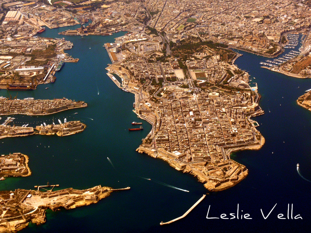
Malta’s Grand Harbour
Growing up as a child before the arrival of computers and video games consoles, feeding one’s imagination rested on creating fantasies by reading books and comics, watching the two black and white television channels which were available and going to see the occasional movie. Living in 1960s and 1970s Malta with relatives who had lived through the bombings of the Second World War, scars of which were still visible all around, military matters constituted a never-ending source of history, mystery and adventure. Couple this with my paternal grandmother’s seafront house on the Vittoriosa waterfront, with its constantly changing and omnipresent activity by the British Royal Navy and the picture becomes complete.
One of my past-times as such a child of the 1960s and ‘70s was to draw imaginary islands which I would populate with cities, hills, valleys and small villages surrounded by fields. My islands would also feature bays and beaches, cliffs and coves and the ubiquitous airports and road networks. But by far, the most impressive of features which my imagination would impose on my imaginary rocky outcrops surrounded by the deep blue sea would invariably be their harbours.
These harbours would inevitably be deep water and capable of hosting the most impressive of fleets. They were embraced by the elongated arms of solid rock, on whose foundations impregnable fortresses and battlements, guarding the entrance through the narrow harbour-mouth stood. Inside, they were subdivided into a number of smaller but similarly impressive basins, between which, tongues of land overflowing with walled citadels and castles would protrude. My imaginary harbours also invariably hosted the island’s capital city and were obviously the centre of all political, commercial and military activity with the rest of the island being devoted to the countryside, the villages, the cliffs and the beaches.

Whilst engaging in this past-time I was unaware of one basic fact: the heavy, subliminal influence which Malta’s Grand Harbour was having on my perception of what a harbour should look like. Decades later, I today understand more than ever before the importance and significance which this harbour has had and will continue to have on Malta’s prospects.
The name Grand Harbour, bombastic as it may seem to those who do not know it, evokes images of greatness. To the Maltese it is simply il-Port il-Kbir, similar to the Italians’ Porto Grande or Great Harbour. But it is the English version with its connotations of grandness, which comes closest to home in appreciating the true wonders of this natural basin, which has ensured that Malta grows larger than life over the centuries to eventually become the sovereign European state it is today.
In my library I have a nineteenth century Dictionary of Geography that describes the Grand Harbour as follows:
“La Valetta is, from its excellent harbour, of great importance as a naval station and a commercial town. The Grand Harbour, on the south-east side of La Valetta, is one of the finest bays in the world. This beautiful basin is divided into five distinct ports, all equally safe, and each capable of containing a considerable number of vessels. The entrance is hardly a quarter of a mile wide, and is commanded on either side by strong batteries. ……”
This short entry contains a host of terms describing this harbour: excellent, finest, beautiful, distinct, safe. And indeed it is, for not only does this harbour deserve each individual adjective extolling its greatness, but it actually deserves them in their accumulated totality.
For a harbour can be beautiful but lack safety. It can be distinct but not excellent or the finest. Grand Harbour is all of these combined, which is what makes it so special. For it is a natural marvel, which gives the impression of having been purposely designed to be one of the finest harbours in the world. And all of this on an almost insignificantly small island-state which can fit very comfortably within the confines of London’s M25 ring-road.

The Grand Harbour consists of the confluence of a number of individual valleys, some very small, and some quite big by Maltese standards, which all drain into the same bay. However, the geology of the place, coupled with millennia of the carving action of water flowing through the soft limestone, have meant that each valley has carved out its own individual little basin, thereby making the Grand Harbour a collection of creeks rather than a single port.
Thus individual valleys on the Cottonera side have carved out Rinella Bay, Kalkara Creek, Dockyard Creek and French Creek. But by far, the valley which has had the largest influence on the Harbour’s formation is the one draining at Marsa: a valley which drains rainwater along the huge watercourses originating in the Siggiewi/Zebbug/Rabat/Mdina highlands and flowing through Attard, Qormi and Marsa. This valley has carved a deep channel that extends for one kilometre from inner Marsa to the harbour mouth where the breakwater is located.

But this is not enough! Under normal circumstances, the effect of such valleys, great as they are within the Maltese context, would only have led to the formation of a series of shallow bays with beaches rather than a deep-water harbour. Grand Harbour actually owes its very existence to a more catastrophic event in Malta’s geological history, as a result of which the entire island was raised in a lopsided fashion through the actions of a massive, underwater tectonic upheaval so that it now slopes in a west to east direction. This explains why most of Malta’s west coast is composed of high sheer cliffs while the east coast consists of indented bays and harbours that dip into deep water quite rapidly.
The upheaval described above caused the shallower bays and harbours on the eastern side of the island to be submerged quite heavily, forming the wonder which is the Grand Harbour. Without this upheaval, the area currently housing the harbour would currently most probably be an extensive valley system gently shelving into the sea somewhere where the breakwater currently stands.
Before the interventions of man, the area around the Grand Harbour must have been a joy to behold. Ancient oak woodlands would have stood on the high grounds where Valletta, the Three Cities and Corradino Heights currently stand. The cliffs leading down to the sea would have sustained bushes and other maquis vegetation, whilst more difficult to visualize would have been the marshes and small islands prevailing in the wetland area between Marsa and Qormi, parts of which were actually beneath sea level thereby retaining pools of brackish water in a veritable Mediterranean saline wetland all year round.
With the arrival of man from Sicily around seven thousand years ago, the area around Grand Harbour started to change as evidenced by the Neolithic remains in Kordin and nearby Tarxien. This besides other settlements which must also have existed in the highly built Cottonera conurbation which has been developed and redeveloped on numerous occasions over hundreds of years ensuring the obliteration of any previous signs of very probable earlier human activity from the Punic, Roman and Arab periods.
Medieval sources make clear references to the emergence of the Castrum Maris, or “Castle by the Sea” as the forebear of today’s Fort St. Angelo. This stronghold in the middle of Grand Harbour led to the development of Malta’s first extensive maritime town, the castle’s burg or Borgo. This town was to later expand into the three distinct entities collectively known as the Three Cities of Vittoriosa, Cospicua and Senglea. Around this time, one of the most important economic activities in Malta was state-sanctioned piracy, with the Grand Harbour being the base for the ships which embarked on these ventures in an open manner and on which taxes were paid to the authorities depending on the returns from each trip! Apart from this, some of the most famous of medieval events to take place within the Grand Harbour which are worth mentioning are the 1283 naval battle which saw the forces of Spanish Aragon oust the Angevins from Malta and the 1425 uprising by the Maltese against their feudal lord Don Gonsalvo Monroy resulting in the imprisonment of his wife Donna Costanza in the Castrum Maris as a hostage.

The arrival of the Knights of St. John of Jerusalem in 1530, who were granted the Maltese Islands and the Port of Tripoli in Libya by the Holy Roman Emperor Charles the Fifth of Spain, against an annual rent of one peregrine falcon, led to the huge transformation of the Grand Harbour. The initially reluctant Knights, whose long-term vision consisted of the eventual recapturing of the much bigger and greener island of Rhodes from the Ottomans, commenced the fortification of the harbour by strengthening the medieval castrum which was renamed St. Angelo, fortifying the borgo and constructing two additional forts, namely St Michael in Senglea, a peninsula parallel to Birgu which they also encircled by a wall and St Elmo, at the tip of the Sceberras Peninsula guarding the harbour mouth.
The successful outcome of the Great Siege of 1565, during which the Knights and the Maltese repelled a 30,000 strong Ottoman invading force, led to the Knights’ decision to establish Malta as their permanent home. The building of Valletta and its suburb of Floriana and their impressive network of fortifications, the expansion of the Three Cities and their subsequent encirclement by the impregnable Cottonera Lines and the huge amount of shipping which the new city state of the Knights started to attract saw the Grand Harbour reach its zenith. The Harbour steadily increased in strategic importance, benefiting from the dual advantage of location and strong defences, until the decline of the Order of the Knights in the late eighteenth century first led Napoleon’s French and subsequently Nelson’s British to take control of the Island, particularly on the realization of the fact that whoever controlled the Grand Harbour effectively controlled shipping movements in the whole Mediterranean.
 The advent of the British Royal Navy, not only gave a new lease of life to the Grand Harbour as the base for Britain’s Mediterranean Fleet, but also led to its industrialization through the strong expansion and development of the ship-repair yards first developed by the Knights. The Dockyards were to become synonymous with the social, economic and political history of the Grand Harbour during the nineteenth and twentieth centuries and were to provide employment to the thousands of people who lived in the districts surrounding the harbour.
The Harbour witnessed strong military activity during the Second World War including incessant dive bombing sorties on military and merchant shipping by the German and Italian air forces, attacks on its ship repair facilities as well as a daring Italian e-boat attack on the defensive net blocking its entrance which was thwarted by a well aimed defensive artillery response which literally blew the attackers out of the water.
 The post war years led to the gradual decline of the Grand Harbour. The closure of the British Military base and the departure of the Royal Navy in 1979 was the first step followed by the gradual decline in merchant shipping movements as Marsaxlokk Harbour steadily developed as the alternative cargo hub for Malta. The downsizing and eventual closure of the ship repair yards and their replacement by a leaner, privatized operation almost led to the eventual demise of the harbour in the first decade of the new millennium.
However, like a phoenix, Grand Harbour is rising once more from the ashes. From cruise ships to super-yachts and from extensive refurbishments to ambitious regeneration projects, the area around Grand Harbour is once again at the heart of Malta’s quest to redefine itself anew for yet another time during its long and chequered history.
Tourism is playing a major role in this latest version of the Grand Harbour: tourism activity which recognizes the natural and historical importance of the harbour and its environs as the Island seeks to attract ever increasing quantities of tourists embarking on city-breaks. Thus, the Harbour and its surroundings become a focal point in themselves, rather than a curious addendum to the experience of a tourist who visits primarily for the island’s coastal charms.
 Grand Harbour has, over the centuries, had a very huge impact on the economic, political and social development of Malta and Maltese statehood. I have always maintained that without its Grand Harbour and its central Mediterranean location, Malta would have been reduced to the same status as its smaller, almost unknown, Italian neighbours of Pantelleria and Lampedusa: with peripheral tourism activity sustaining a small population of fishermen and subsistence farmers.
Meanwhile it continues to be a joy to behold. Whether experienced from three hundred metres up through the window of a descending aircraft, from the deck of a cruise ship as it sails by the impressive battlements or from vantage points such as Valletta’s Barrakka Gardens, Senglea Point or Bighi, it is indeed impressive and a source of pride for the Maltese. And after more than fifty years of endless visits, I have to confess that it is one of the few places in Malta which continues to give me a tingling sensation at the back of my neck every time I view it!