Filfla: a rocky outcrop with a story to tell
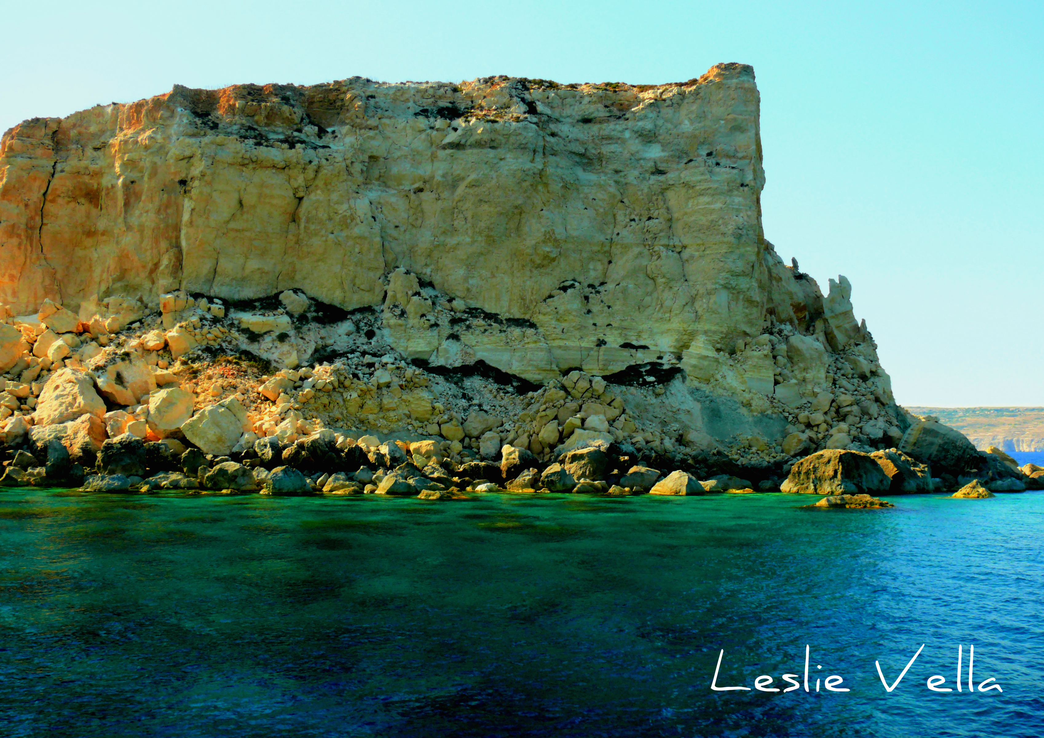
Placed anywhere else, tiny Filfla would go mostly unregarded: a tiny outcrop of limestone, standing some 5 kilometres out in the open sea; defiant and resolute against all that the elements throw at it.
But not in Malta, where a small surface area and a high population density means that every single hectare of land has its use, its role and its history. Even a small place like Filfla.
The islet is a small, rocky platform which was originally attached to the south-west coast of Malta. An ancient cataclysmic event, resulting in the Maghlaq Fault on the main island tore Filfla away from its parent, like some boulder thrown out to sea, thereby converting it from a nondescript section of coast into the separate entity that we know today.

It must have once been bigger, of course. But millennia of pounding by the deep blue Mediterranean which surrounds it, accelerated with its more recent misfortune to have served as a sitting-duck target for British warships engaging in gunnery target practice have led to the islet losing a lot of its original mass with today’s surviving chunk looking like the battered hulk of a fortress which has been subjected to a massive and merciless bombardment.
The name Filfla has its roots in the Arabic word for chili pepper, filfel. The name probably originated either due to the islet’s miniscule size or its original shape which may have reminded observers from the Maltese mainland of a small chili. There is absolutely no evidence to suggest that chili was ever cultivated on the island given its small size and its remoteness so the name is most probably descriptive of shape or size rather than associated with produce. Maps from five hundred years ago refer to the island as Piper, which is the Latinised form of filfel. This indicates that Filfla’s name is at least of Semitic origin from the time of the Arab period around one thousand years ago. I am not aware of any older references to the island and its name in classical times.

According to historical sources there used to be a small structure on the island, dating back to the fourteenth century, which doubled up as a place of worship and a store of food and water for fishermen stranded upon it in times of bad weather. The chapel was deconsecrated in 1575 and apparently the cave housing this chapel/food depot collapsed after an earthquake in 1856 that also sank part of the island. A late medieval painting showing strong renaissance influences which is found in the vestry of the parish church of the nearby mainland village of Zurrieq is popularly known as the “Madonna ta’ Filfla” triptych and is popularly assumed to have once adorned the Filfla chapel, although doubts exist whether a painting of such quality would have been commissioned to sit in such a rather deserted chapel.
Some sources also refer to a fresh water spring which provided a source of drinking water: something entirely feasible given that at sea level, Filfla sports a layer of impermeable blue clay implying that it could support a tiny, rainwater-fed, perched aquifer which recharged annually during the rainy season, eventually leaking out through a spring.
Filfla’s location most probably had a strong bearing on the location of the two imposing prehistoric complexes of Hagar Qim and Mnajdra on the Qrendi coast with some historians speculating that the mysterious offshore rock, silhouetted against the midday sun on the southern horizon, may have possessed some symbolic or sacred significance of context to the two magnificent temples and stone calendars located within 500 metres of each other.

In more recent times, it was the beauty of the setting, with the gently sloping cliffs on one side and the islet on the other that led the British Governor of Malta Sir Walter Norris Congreve to request burial at sea at a midway point between the two in 1927, thus immortalizing his name by lending it to the aptly named Congreve Channel to the body of water stretching out to Filfla.
Filfla’s major involvement in the international arena took place when the Maltese Government unsuccessfully tried to convince the International Court of Arbitration in The Hague to include it in their deliberations when calculating the median line between Maltese and Libyan waters as a result of a dispute which arose between the two countries for oil-exploration purposes in the early 1980s.
Filfla is a flat-topped plateau which from the distance makes it comparable to a ship. This unfortunate association led to the commencement of a tradition by the British Navy of using Filfla as a target for naval bombardment practice. This action, unthinkable today, but entirely feasible and virtually unopposed in those less sensitive times, created two problems for the isle and its environs. First of all it damaged the soft rocky structure of Filfla resulting in extreme fragmentation and huge amounts of rubble along its sides.

Furthermore, it also resulted in a huge amount of unexploded ordnance lying idle in the relatively shallow waters surrounding Filfla, obviously originating from the hundreds of unexploded shells which missed their mark. While a land-based target-practice range can be regularly cleared of such unexploded ordnance, nothing of the sort was ever done beneath the surface of Filfla’s seas, allowing individuals to dive and retrieve the explosives for conversion into festive fireworks: an eccentric but also dangerously irresponsible past-time. To this day, fishing is prohibited within a one nautical mile radius of Filfla to reduce the risk of netting any unexploded shells.
However, every dark cloud has its silver lining. The isolation, the destruction and the dangers lurking beneath the waves have in a way also led to the protection of Filfla and its evolution into an off-limits nature reserve of international importance. It plays host to an endemic species of lizard not found anywhere else on the planet. In fact the lizard species, which is described as large green with bluish spots is actually a subspecies of the one found on the Maltese islands but differs enough to qualify for a separate subspecies title, the Filfla lizard. And contrary to popular legend and misconception, the Filfla lizard does not have two tails! The legend stems from a reasonably common occurence worldwide when lizards who partially drop their tails instead of losing it in full, grow a new one next to the stump of the older one making it look as if they have two tails!
Amazingly, the islet also supports one of the largest known colonies in the world (five to eight thousand pairs) of the European Storm Petrel, Hydrobates pelagicus melitensis, the appropriately named Kangu ta’ Filfla: quite an achievement for an island the size of two football pitches. It also has extensive nesting populations of shearwaters and yellow legged gulls who prefer the undisturbed and unlit cliffs of Filfla to those of the nearby mainland to set up their breeding grounds. The cracks in the rock and the spaces in the boulder scree created by the historical bombardment seem to play an important role in Filfla’s attractiveness as a bird colony. The islet’s flat top is characterized by coastal garigue vegetation together with a species of giant leek which is very common. Dry during the summer months, the surface becomes a very lush green in winter. An endemic species of snail has also been recorded.

A small rocky shoal is also visible very near to Filfla, possibly the remnant of what the islet used to extend to. This tiny rock, barely above sea level is known by several names, amongst which Il-Gebla ta’ Xutu (Xutu’s rock), Santa Maria and Filflett (as a diminutive of Filfla).
For the past few decades, Filfla has enjoyed the status of ‘site of scientific importance’ and is strictly off limits to visitors: a fitting culmination following the depredations it has suffered at the hands of man. So, when in the South West of Malta, do stop and have a long look at Filfla. As in many others things in Malta, it is the ultimate proof that size does not matter, and that even the most negligible of rocky outcrops over here has a larger than life role both in terms of its natural and its historical attributes!